Lance Armstrong Bikeway problems
This page is a placeholder for future discussion of design problems in the
Lance Armstrong Crosstown Bikeway.
 An example
of the hazards
of an inadequately separated bikeway in California. Does this look like
a facility that would get you off 5th or 6th Street if you were travelling across
town? This is the kind of facility currently proposed for the stretch of the
bikeway between roughly Shoal Creek and Mopac; and the location currently proposed
is on the north side of Cesar Chavez Blvd. directly abutting the hike&bike
trail spur which leads from Lamar Blvd. through a culvert to the south side
of the road. This is the kind of thing I expect to see on a facility like the
one proposed.
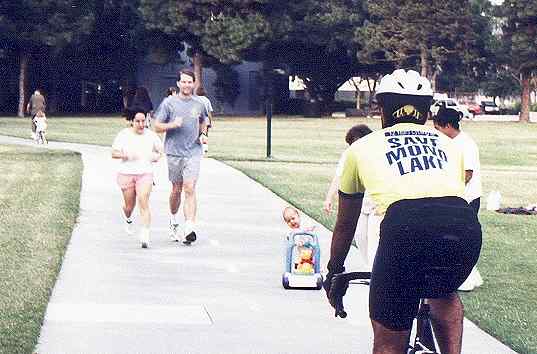
An example
of the hazards
of an inadequately separated bikeway in California. Does this look like
a facility that would get you off 5th or 6th Street if you were travelling across
town? This is the kind of facility currently proposed for the stretch of the
bikeway between roughly Shoal Creek and Mopac; and the location currently proposed
is on the north side of Cesar Chavez Blvd. directly abutting the hike&bike
trail spur which leads from Lamar Blvd. through a culvert to the south side
of the road. This is the kind of thing I expect to see on a facility like the
one proposed.
East Austin - Green Route Signs
For a stretch of the facility, nothing more than green Bike Route signs is
being provided. (Not even painted bike lanes!)
Central Austin - 4th/3rd Streets
This seems to have been resolved in favor of 4th Street. However, attention
needs to be focused on signalization treatments at intersections.
Central West Austin - Shoal Creek to Lamar
Thanks to the Seaholm debacle, the current recommended routing by staff takes
the bikeway down the Shoal Creek trail (with an inadequate turning radius) to
just north of Cesar Chavez Blvd.
West Austin - Lamar to Mopac
Facility is proposed for immediate north side of Cesar Chavez for most of this
route. This and the above section results in more crossings of side streets
than would be necessary with the original proposed route; and connects poorly
with bicycle destinations.